Cusco – Geography and Climate
Cusco has a diverse geography full of mountains, rivers and lagoons. This geography also marks the constant change of climates and microclimates in the region. Get to know areas of great geographical wealth such as the Sacred Valley of the Incas, the Ausangate mountain, the Vilcanota River and more. Today, the geography and characteristic climate of Cusco in Peru.
Content
Location of Cusco
Cusco is the first tourist destination in Peru and South America. It has 13 provinces being the city of Cusco, the capital and urban center of the department. Its territory includes Andean mountains as well as jungles and rivers.
Location of the department of Cusco in Peru
- The department of Cusco is located in southern Peru in South America.
- Geographically it is located in the Peruvian Andes Mountains. However, its territory (71,086 m2) also includes a vast area of jungle.
- It limits to the north with the departments of Ucayali and Junín. To the south with the departments of Arequipa and Puno. To the east with the department of Madre de Dios. And to the west with the departments of Apurímac and Ayacucho.
Location of the city of Cusco
- Cusco or Cuzco is the capital province of the department of the same name.
- It is located in the center of the department, in the heart of the Andes Mountains of Peru. It borders the provinces of Anta, Calca, Paruro, Quispicanchis and Urubamba.
- Cusco was also the capital of the Inca Empire as well as one of the most important cities during the Spanish Colony.
How many provinces does the department of Cusco have?
The department of Cusco has 13 provinces:
- Acomayo.
- Anta.
- Calca.
- Gray hair.
- Canchis.
- Cuzco.
- Chumbivilcas.
- Espinar.
- The Convention.
- Paruro.
- Paucartambo.
- Quispicanchi.
- Urubamba.
Demographics
- The department of Cusco has a total population of 1,316,729 inhabitants (2017).
- The city of Cusco is one of the most populated in Peru with 428,450 inhabitants (2017).
What are the coordinates of Cusco?
- These are the coordinates of the department of Cusco in degrees, minutes and decimals:
- Longitude: O71 ° 58’2.42 “Latitude: S13 ° 31’21.5”
How to get to Cusco?
As the first tourist destination in Peru, Cusco has an airport that receives flights from the city of Lima (capital of Peru). Although most tourists arrive by air (1 hour of travel), it is also possible to do so by road through a bus trip (20 hours of travel, approximately).
How to get to Cusco from abroad?
- To visit Cusco from abroad you must necessarily take a flight to the airport in Lima (capital of Peru).
- From Lima (Jorge Chávez airport), you must take another flight to the city of Cusco (Velasco Astete airport).
These are the countries that have direct flights to Lima:
- South America: Argentina, Bolivia, Brazil, Chile, Colombia, Ecuador, Paraguay, Uruguay and Venezuela.
- Central and North America: United States, Canada, Mexico, Costa Rica, Cuba, Dominican Republic.
- Europe: Spain, France, Holland, England.
How to get to Cusco from Lima?
- Cusco is located 1,101 kilometers away from the city of Lima (by road).
- There are 2 ways to go from Lima to Cusco: a) by road or b) by plane.
How to get to Cusco by plane?
- The trip from Lima to Cusco by plane takes approximately 1 hour.
- There are several airlines to choose from, such as: Sky Airline, Viva Air, Latam, Avianca, Peruvian and Star Peru.
- It is recommended to buy the plane ticket online and in advance.
How to get to Cusco by bus?
- The trip from Lima to Cusco by bus takes approximately 20 hours (direct route).
- The trip from Lima to Cusco by bus along the Arequipa route takes 25 hours.
- There are several companies to choose from. Most of the land terminals such as: the land terminals in the center of Lima or the land terminal in the south of the city.
- Bus tickets from Lima to Cusco can be purchased directly at the land terminals.
Cusco map
Cusco derives from the word ‘Qosqo’ which in Quechua (the language of the Incas) means ‘Navel of the world’. Its name is due to the fact that it was the capital of the Inca empire, which included the current territories of Peru, Bolivia, Ecuador and part of Chile and Argentina.
Map of Cusco in the world
- Cusco is one of the most touristic cities in the world. It is located in the Andes Mountains of Peru in South America.
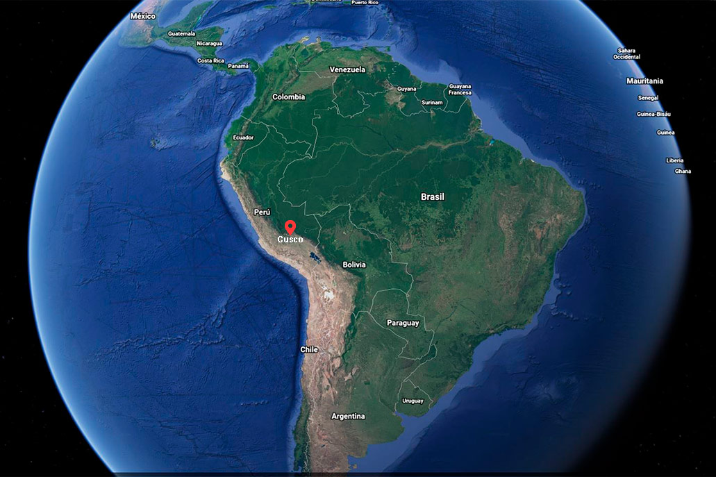
* Source: Google Maps.
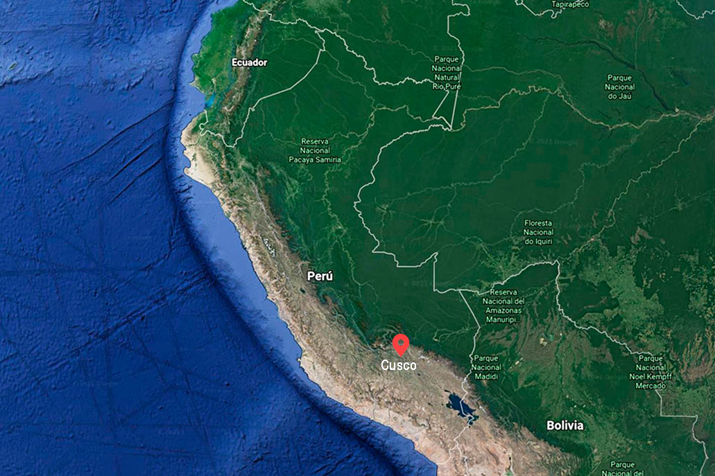
Map of Cusco in South America
- Cusco is one of the most touristic cities in South America. Its capital, the city of Cusco is located 3,399 meters above sea level (11,151 ft).
* Source: Google Maps.
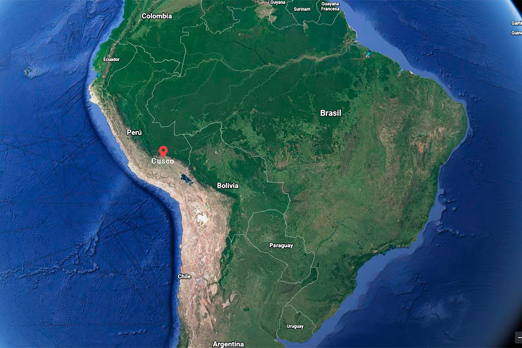
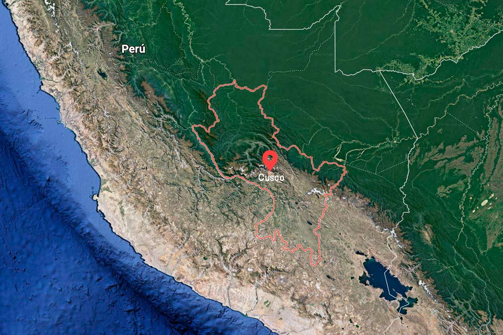
Map of Cusco in Peru
- Cusco is the main tourist destination in Peru. It is located in the southern part of the country of the Incas. Its territory includes mountainous landscapes as well as tropical forests.
* Source: Google Maps.
Cusco map
- Cusco is one of the 24 departments that make up Peru. Its territory covers 71,986 square kilometers.
* Source: Google Maps.
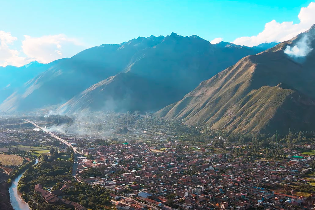
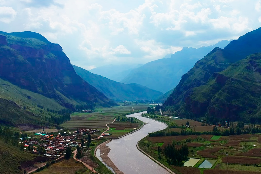
The Sacred Valley of the Incas
The Sacred Valley of the Incas is one of the areas geographies in Cusco. It was considered a place of great importance for the Incas due to its mountains, rivers, lagoons and cultivated fields. Currently it is mainly made up of the towns of Chinchero, Pisac, Maras (Moray), Urubamba, Ollantaytambo, Calca and more.
Chinchero
Chinchero is one of the most traditional towns in Cusco since it preserves many of the ancient Inca traditions. This town combines culture, history, archeology and a unique nature.
Chinchero was an important strategic point for the Incas (the palace of the Inca Túpac Yupanqui was built there. Currently, it preserves the platforms and base structures of the ancient splendor. During the colony the church was built there ‘Our Lady of Monserrat de Chinchero’.
Height – Chinchero is 3,754 meters above sea level (12,316 ft).
Location – Chinchero is only 30 kilometers (by road) from the city of Cusco.
Geography – Chinchero is located in the highest part of the Sacred Valley of the Incas. It is surrounded by mountains and two lagoons: Huaypo and Piuray.
Tourist attractions- Inca archaeological site of Chinchero.
- Our Lady of Monserrat de Chinchero colonial church.
- Chinchero Textile Centers.
Pisac
Pisac is famous for hosting one of the oldest artisan markets in Cusco and Peru. Its inhabitants preserve many of the Inca traditions. In this town the Inca city of Pisac was built, an urban and religious site famous for its constructions such as: towers, platforms, temples, tunnels, walls and more.
Pisac developed for many years a Sunday fair where the characteristic products of the region were traded (with money or through barter): potatoes, corn, textiles, etc. Today, over the years, a craft market was created where you can buy at a good price: ceramics, textiles, jewelry, handicrafts and more.
Height – Chinchero is 3,762 meters above sea level (12,342 ft).
Location – Pisac is only 34 kilometers (by road) from the city of Cusco.
Geography – Pisac is one of the most representative towns of the Sacred Valley of the Incas due to its beautiful mountainous geography. The Vilcanota River runs through the town. At the highest part of a mountain is the Inca archaeological site of Pisac.
Tourist attractions- Inca archaeological site of Pisac.
- Pisac craft market.
- Colonial temple of Pisac ‘San Pedro Apóstol’.
Maras
Maras is a town founded during the Spanish viceroyalty and famous for hosting a beautiful landscape as well as the popular ‘Salineras de Maras’. This town preserves many of the Inca traditions of its ancestors. Its population is mainly dedicated to agriculture and livestock.
The town of Maras has narrow streets made of somewhat steep stone. The houses are mostly made of adobe and retain the titles or shields that their owners used in the colony. Today, there are restaurants and small hotels to house tourists who come there to visit the ‘Salineras de Maras’ and the ‘Andenes Incas de Moray’.
Height – Maras is 3,300 meters above sea level (10,826 ft).
Location – Maras is located 41 kilometers (by road) from the city of Cusco.
Geography – Maras is a unique place in the Sacred Valley of the Incas. From its location you can see the immense snow-capped mountains Verónica and Chichón.
Tourist attractions- Salineras de Maras.
- Inca terraces of Moray.
- Colonial temple of San Francisco de Asís de Maras.
Urubamba
Urubamba is one of the most important towns in the Sacred Valley of the Incas. It is the capital of the province of the same name and one of the most touristic towns in Cusco.
Urubamba is famous for its pleasant climate. The town has various tourist services such as: restaurants, hotels, cafes and more. Although there are no important Inca archaeological remains (the old palace of Huayna Cápac is in poor condition); the town preserves its Catholic temples such as the church of San Pedro Apóstol.
Urubamba is also famous for being the scene of several adventure sports such as: canoeing, rock climbing, paragliding and more.
Height – Urubamba is 2,871 meters above sea level (9,419 ft).
Location – Urubamba is located 53 kilometers (by road) from the city of Cusco.
Geography – Throughout the town of Urubamba crosses the Vilcanota River. At the top, the Chicón and Pumahuanca mountains stand out.
Tourist attractions- Colonial temple of San Pedro Apóstol de Urubamba.
Ollantaytambo
Ollantaytambo is the only town that has preserved its Inca urban design for hundreds of years. It also has an Inca citadel with huge and famous buildings such as: the Royal House of the Sun, the Temple of the Sun, the Ñusta Bath, the platforms and much more.
Ollantaytambo is considered the end point of the Sacred Valley of the Incas. It is also considered the gateway to the high jungle of Cusco. It is precisely in Ollantaytambo that the train is boarded in the direction of Machu Picchu.
Walking through the narrow and cobbled streets of Ollantaytambo is to peek through the history of the Incas: you can see Inca walls attached to colonial walls and modern constructions.
The town of Ollantaytambo preserves some of its oldest traditions. Its colonial temple, the Church of Santiago Apóstol was built in 1650. The main festival in the town is the Bajada de Reyes, celebrated on January 5.
Height – Ollantaytambo is 2,792 meters above sea level (9,160 ft).
Location – Ollantaytambo is located 72 kilometers (by road) northeast of the city of Cusco.
Geography – Ollantaytambo has a rugged geography. The Urubamba River crosses one of its limits. The village is located on the slopes of a mountain. From there you can see the Verónica and Halancoma peaks.
Tourist attractions- Inca archaeological site of Ollantaytambo.
- Town of Ollantaytambo.
- Colonial temple of San Pedro Apóstol de Ollantaytambo.
Calca
Calca is one of the least known towns in the Sacred Valley of the Incas. Due to its strategic location with the towns of the Cusco jungle, it has an important role in trade with the Cusco towns.
Near the town of Calca is the archaeological site Huchuy Qosqo, a Quechua word that means ‘small Cusco’. Unfortunately, this Inca site is not in good condition.
In Calca you can also enjoy other tourist attractions such as the thermal medicinal baths of Machacancha and Minasmoqo. You can also appreciate its squares and its colonial church ‘San Pedro Apóstol’.
Very few tourists dare to visit Calca. This town preserves some of the oldest Inca traditions. From there you can visit other places in Cusco such as Urubamba or Lares.
Height – Calca is 2,925 meters above sea level (9,596 ft).
Location – Calca is located 51 kilometers (by road) northeast of the city of Cusco.
Geography – Calca is located in the Vilcanota valley. It has a fertile territory crossed by the Vilcanota River. It is surrounded by the snowy Colque Cruz.
Tourist attractions- Colonial temple of San Pedro Apóstol de Colque Cruz.
- Thermal medicinal baths of Machacancha.
- Thermal medicinal baths of Minasmoqo.
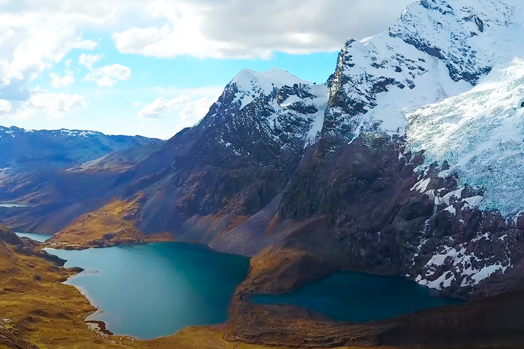
The snowy Ausangate
Ausangate is the highest mountain in Cusco (the fifth highest in Peru). In the time of the Incas he was recognized as one of the most important ‘Apus’ (gods of the mountains) of the empire. Currently there are hiking trails up the high slopes of this summit. On the north side, the traditional religious celebration is celebrated in honor of the ‘Lord of Qoyllur Rit’i, one of the most massive pilgrimages in Andean places on the planet. Today’s Cusco residents also pay respect to the Ausangate mountain, just as the Incas did hundreds of years ago.
Location – The Ausangate mountain is located in the Cordillera de Vilcanota in Cusco. The snowy is located southeast of the city of Cusco. The closest town is Ocongate.
Height – The snowy Ausangate reaches a maximum height of 6,384 meters above sea level (20,944 ft).
Map – The Ausangate has nearby lagoons of which the Sibinacocha lagoon stands out. The closest town is Pitumarca. One of the most important tourist attractions nearby is the Mountain of the 7 Colors.
* Photo: Google Maps.
Temperature – The snowy Ausangate has a cold climate due to its elevation. The temperature varies from -17ºC. (1.4ºF). at 0 ° C. (32ºF).
Geography – The Ausangate mountain has high elevation mountains where the ichu (wild herb) is characteristic. You can also appreciate the beautiful lagoons such as: the Yanacocha lagoon, Pucacocha and the Sibinacocha.
The Vilcanota River
The Vilcanota River is one of the main rivers in Cusco along with the Apurímac River. It rises from the high peaks of the snowy Cunurana, 5,443 meters from the sea (17,857 ft). It travels approximately 650 kilometers until it flows into the Ucayali River (the largest in Peru) in the jungle. When it crosses the Urubamba River, its name changes to ‘Urubamba River’. Much of its route was used for the cultivation of the Incas as in the Sacred Valley of the Incas and Machu Picchu.
Location – The Vilcanota River is located in southern Peru in the mountains of Cusco. Travel a large part of the territory through the ancient Inca citadels. It is divided into two: a) the Vilcanota River (upper Urubamba), which runs through Andean mountainous geographies and Inca archaeological sites and b) the Urubamba River (lower Urubamba) that descends vertiginously through jungle landscapes until it flows into the Ucayali River in the jungle down from Peru.
Archaeological sites that the Vilcanota River runs through – The Vilcanota River runs through various Inca archaeological sites, such as:
- Raqchi.
- Piquillacta.
- Pisac.
- Huchuy Qosqo.
- Ollantaytambo.
- Machu Picchu.
Tributaries – The main tributaries of the Vilcanota River are.
- The Tambo River.
- The Yavero River (Paucartambo).
- The Huarocondo river.
- The Chapo River.
- The Yanatile River.
- The river Camisea.
- The Sepa river.
- The Paquiria River.
- The Huacayoc River.
Map – The Vilcanota River is famous because it travels all the way by train from the town of Ollantaytambo to Aguas Calientes (Machu Picchu town). It offers tourists one of the most beautiful landscapes of the trip to Peru.
* Photo: Google Maps.
Flora and fauna – The Vilcanota River is home to countless species of plants and animals. The most popular are the Andean bear (also known as the spectacled bear), the condor, the torrent duck and orchids and their more than 400 species in the Historic Sanctuary of Machu Picchu.
Animal and bird species in the Vilcanota river:
- Duck of the torrents.
- Water blackbird.
- Andean condor.
- Thongs.
- Hummingbirds.
- Andean bear.
- Sachacabra.
Plant and flower species in the Vilcanota river:
- Capulí.
- Bluebells.
- Data.
- Orchids.
- Pisonay.
- Lianas.
- Bromeliads.
Geography
- The pongo de Mainique (a canyon of descent and vertiginous currents) divides the Vilcanota river in two: the upper Urubamba and the lower Urubamba.
- The upper Urubamba runs through Andean landscapes and Inca constructions such as Pisac, Ollantaytambo and Machu Picchu.
- The lower Urubamba runs through the jungle landscapes of Peru until it flows into the Ucayali River (a river that later joins the Marañón River to form the famous Amazon River).
The weather in Cusco
Cusco has a varied climate. Its territory is divided into Andean mountains (cold – temperate climate) and semi-tropical forests (warm – humid climate). Each of its provinces (13 in total) has a particular climatic characteristic due to the characteristics of its geographies.
The climate in the department of Cusco
- The department of Cusco has two distinct types of seasons: the rainy season and the dry season.
- The rainy season runs between November and March. It is characterized by frequent rains (especially in February).
- The dry season runs from April to October. It is characterized by the infrequency with which rains occur (especially between May and June).
The weather in the city of Cusco
- The city of Cusco is the main city of the department. There is the only airport in the region: Velasco Astete airport.
- The climate has 2 seasons during the year: dry season and rainy season.
- During the dry season (from April to October) the minimum temperature is 0ºC. (32ºF). The maximum temperature is 19ºC. (66ºF.)
- During the rainy season (from November to March) the minimum temperature is 4ºC. (39ºF). The maximum temperature is 21ºC. (69ºF).
The climate in the Sacred Valley of the Incas
- The Sacred Valley of the Incas has a diverse climate depending on the time of year and the town where it is located.
- As in the rest of Cusco, there are two seasons during the year: the dry season (from April to October) and the rainy season (from November to March).
These are the towns and their maximum and minimum temperatures:
Town | Temp. maximum | Temp. minimum | Temp. average |
|---|---|---|---|
| Chinchero | 19ºC. (66ºF.) | – 2ºC. (28ºF.) | 8ºC. (46ºF.) |
| Pisac | 22ºC. (71ºF.) | 3ºC. (37ºF.) | 13ºC. (55ºF.) |
| Maras | 20ºC. (68ºF.) | 0ºC. (32ºF.) | 12ºC. (53ºF.) |
| Urubamba | 23ºC. (73ºF.) | 4ºC. (39ºF.) | 13ºC. (55ºF.) |
| Ollantaytambo | 24ºC. (75ºF.) | 4ºC. (39ºF.) | 14ºC. (57ºF.) |
| Calca | 25ºC. (77ºF.) | 5ºC. (41ºF.) | 15ºC. (59ºF.) |
The weather in Machu Picchu
- Machu Picchu belongs to the Aguas Calientes district (Urubamba province). It has a warm temperate climate with plenty of rain (especially in February). However, most of the day provides optimal heat for visiting the Inca City.
- Like the rest of Cusco, Machu Picchu has two seasons during the year: the dry season (from April to October) and the rainy season (from November to March).
- The maximum temperature in Machu Picchu is 27ºC. (80ºF.). The minimum temperature is 8ºC. (46ºF.). The average temperature is 17ºC. (62ºF.).
The climate in the provinces of Cusco
- Cusco has 13 provinces. Most are located in Andean regions where the climate is temperate cold. The province of La Convencion is located in the high jungle of Cusco, where the climate is warm.
These are the provinces of Cusco and their maximum and minimum temperatures:
Town | Temp. maximum | Temp. minimum | Temp. average |
|---|---|---|---|
| Acomayo | 21ºC. (69ºF.) | – 1ºC. (30ºF.) | 11ºC. (51ºF.) |
| Anta | 20ºC. (68ºF.) | 0ºC. (32ºF.) | 10ºC. (50ºF.) |
| Calca | 25ºC. (77ºF.) | 5ºC. (41ºF.) | 15ºC. (59ºF.) |
| Canas | 18ºC. (64ºF.) | – 2ºC. (28ºF.) | 9ºC. (48ºF.) |
| Canchis | 21ºC. (69ºF.) | – 4ºC. (24ºF.) | 10ºC. (50ºF.) |
| Cuzco | 22ºC. (71ºF.) | 0ºC. (32ºF.) | 12ºC. (53ºF.) |
| Chumbivilcas | 20ºC. (68ºF.) | – 2ºC. (28ºF.) | 11ºC. (51ºF.) |
| Espinar | 19ºC. (66ºF.) | – 4ºC. (24ºF.) | 8ºC. (46ºF.) |
| The Convention | 32ºC. (89ºF.) | 15ºC. (59ºF.) | 24ºC. (75ºF.) |
| Paruro | 21ºC. (69ºF.) | 1ºC. (33ºF.) | 12ºC. (53ºF.) |
| Paucartambo | 22ºC. (71ºF.) | 3ºC. (37ºF.) | 13ºC. (55ºF.) |
| Quispicanchi | 22ºC. (71ºF.) | 0ºC. (32ºF.) | 13ºC. (55ºF.) |
| Urubamba | 23ºC. (73ºF.) | 4ºC. (39ºF.) | 13ºC. (55ºF.) |
By Machupicchu Terra – Last updated, May 20, 2026
All-inclusive Machu Picchu Tour!
- ✔ Hotel pickup
- ✔ Train journey through the Sacred Valley
- ✔ Specialized bilingual guide
- ✔ Entrance to Machu Picchu
Enjoy an unforgettable experience in Machu Picchu on a 1-day tour. Discover the Temple of the Sun, the Intihuatana, and other Inca structures surrounded by unique landscapes. Includes entrance to Machu Picchu and special benefits for students.