The province of Castilla in Arequipa
The province of Castilla in Arequipa is one of the most touristic due to tourist attractions such as: the Majes canyon, the valley of the volcanoes, the Toro Muerto petroglyphs and the archaeological remains of Antaymarca. Its capital is the district of Aplao, located only 617 meters above sea level. However, the province extends through valleys and mountains reaching altitudes above 5,000 meters above sea level. Learn more about this Arequipa province!
All about the province of Castile
Explore the province of Castile
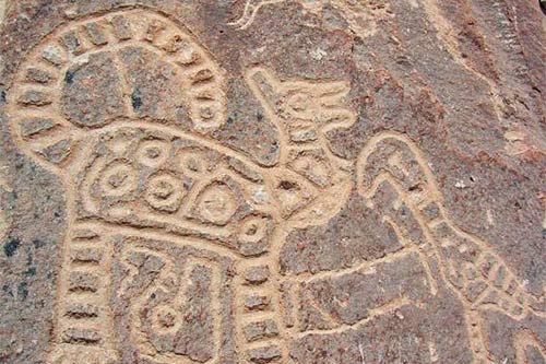
1 Toro Muerto in the Majes valley
In Toro Muerto there are more than 6 thousand engravings on stones in an area of more than 5 km². It is located in the Majes Valley, 3 hours by car from Arequipa.
The province of Castilla in Arequipa
Castilla is one of the eight provinces that make up the department of Arequipa. Its name was chosen on March 7, 1854 by 410 residents of the Majes Valley in honor of Marshal Ramón Castilla. A few days later, on March 21, 1854, the province was created.
The province is made up of fourteen districts: Andahua, Ayo, Chachas, Chilcaymarca, Choco, Huancarqui, Machaguay, Orcopampa, Pampacolca, Tupán, Uñón, Uraca, Viraco and Aplao. The latter is the capital.
The fourteen districts, in turn, can be divided according to the three divisions of basins and sub-basins: a) Lower Castilla (Uraca-Corire, Huacarqui and Aplao districts), b) Middle Castilla (Viraco, Uñón, Tipán, Pampacolca and Machaguay) and c) Castilla Alta (districts of Chilcaymarca, Orcopampa, Molloco, Choco, Chachas, Ayo and Andagua).
The Aplao district is located at 617 meters above sea level in the Majes and Camanacon river basin. However, the province also covers high altitudes that reach more than 5 thousand meters above sea level.
Geographically, the province can be divided into five landscapes or zones: a) structural plateau (from 1,000 to 1,800 meters above sea level), b) mountains and hills (from 1,800 to 2,500 meters above sea level), c) mountain slopes (from 2,500 to 3,900 meters above sea level), d) high plateau (from 4,000 to 5,000 masl) and e) nival mountain range (5,000 to 5,800 masl).
Castilla covers a total area of 6914.48 square kilometers. According to the 2017 census, it has a total population of 33,629 inhabitants. The predominant languages are Spanish and Quechua.
The history of the province goes back more than fifteen hundred years ago. This is demonstrated by the petroglyphs of Toro Muerto, a set of about 5 thousand rocks carved with zoomorphic figures whose antiquity ranges from 500 AD. and 1,300 AD.
However, in Castilla there are many other tourist attractions that are worth visiting, such as: the Majes canyon, the valley of the volcanoes, the Toro Muerto petroglyphs, the Querulpa Jurassic park and the archaeological remains of Antaymarca.
Where it is located?
The province of Castilla is located in the south of Peru in the department of Arequipa. It is 178 kilometers by road from the city of Arequipa and 959 kilometers from the city of Lima.
The province limits to the south with the province of Camaná, to the east with the province of Caylloma and to the north and west with the province of Condesuyos.
How to get to the province of Castilla from Arequipa?
To get to the province of Castilla from the city of Arequipa, you must follow this route:
- From any part of the city of Arequipa you must take a taxi or public transport to the land terminal, located on Los Incas avenue.
- From the land terminal, take a public transport or collective taxi to the town of Aplao, capital of the province of Castilla. The trip takes approximately 3 hours 20 minutes. The cost of the trip varies between 20 to 30 Peruvian soles.
- From Aplao you can visit the other towns that make up the province of Castilla.
Castilian history
The known history of the province of Castilla goes back more than 1,500 years ago. Between 500 AD and 1,300 AD. Engravings were made on more than 5,000 rocks that today make up the famous Toro Muerto petroglyphs. This manifestation of rock art in the Majes valley was made by the first ethnic groups that inhabited the place.
In the 15th century, the upper parts of present-day Castile were occupied by the Collagua culture (of Aymara language) who were annexed to the Inca empire. As a testimony of this occupation, the archaeological site of Antaymarca can be seen today, made up of squares, houses, agricultural areas, all made of mud, clay and stone.
In colonial times, the Majes valley that makes up the province of Castilla was used for agriculture and livestock under the command of the encomenderos and later the landowners. On March 7, 1854, 410 inhabitants of the Majes Valley decided to name a new province which they called ‘Castilla’, in honor of Marshal Ramón Castilla. A few days later, on March 21, 1854, the province was created.
Today the province of Castilla offers some of the most interesting tourist attractions in the Arequipa region. Places such as: the Majes canyon, the valley of the volcanoes, the petroglyphs of Toro Muerto and the archaeological remains of Antaymarca stand out.
What tourist attractions does the province of Castilla have?
- Majes canyon – This canyon has a depth of 4,100 meters, which is why it is considered the deepest in the world (from Lucrecia Hill). Due to its Andean geography, there you can do adventure sports such as canoeing or hiking. The town of Majes is 99 kilometers from the city of Arequipa.
- The valley of the volcanoes – As its name indicates, this high Andean valley (exceeds 3,600 meters above sea level), is surrounded by volcanoes such as Antaymarca, Shipee, Jonson and Pucamauras. Everywhere you can see remains of volcanic lava formed thousands of years. It is 334 kilometers by road from the city of Arequipa.
- The petroglyphs of Toro Muerto – These petroglyphs date back between 500 AD. and 1,300 AD. They cover an area of 3,876 square meters. In the more than 5 thousand stone blocks of the place, thousands of bas-relief engravings by the inhabitants of the place can be distinguished. The zoomorphic and geometric figures would have been made in 800 AD.
- Antaymarca archaeological site – Antaymarca was a citadel of Collagua origin (ethnic group of Aymara language) that inhabited the place before the conquest of the Incas. The site consists of squares, enclosures, roads, agricultural sectors and collective graves made of mud and stone. They are near the town of Orcopampa.
- Querulpa Jurassic Park – This innovative tourist attraction displays sculptures made of fiberglass representing giant dinosaurs. The project was carried out in 2005. The reason is that up to 69 dinosaur footprints were found there. It is located on the Querulpa hill, in the Aplao district (about 3 hours 30 minutes from the city of Arequipa).
Weather in Castile
The climate in the province of Castilla varies according to its varied Andean geography. Its capital, Aplao, is located in the Majes Valley, a warm area with temperatures that vary from a maximum of 32ºC. up to a minimum of 12ºC. The rains are few, with an annual average of 5.6 mm.
More information about the province of Castilla
The province of Castilla offers different festivities that are worth knowing. The province’s anniversary on March 21 stands out (with activities such as serenades in Aplao). In addition, on September 8, the festival is celebrated in homage to the Virgen de los Remedios. Likewise, on October 20 in the Viraco district, the Virgen del Sombrero is celebrated.
In Castilla you can also visit tourist attractions such as the Quiscay suspension bridge (which crosses the Majes river). The bridge is presumed to have an Inca origin. It is made of wooden logs.